THE FAMOUS MERCATOR AND HONDIUS ATLAS IN THE 1630 EDITION
The Atlas sive Cosmographicae meditationes de fabrica mundi et fabricati figura is undoubtedly one of the most important and significant works in the history of cartography. The renowned Flemish cartographer Gerard Mercator (1512–1594), famous for introducing the "Mercator projection" in 1569—still essential for navigation today—and for being a pioneer of scientific cartography, began publishing his Atlas in 1585. A second part, covering Italy, Greece, and the Balkan Peninsula, was published in 1589. After Mercator's death, his son Rumold released the third part, reprinting the first two sections and adding a biography of his father.
Hondius' Addition to the Atlas
In 1604, Jodocus Hondius (1563–1612), likely through Cornelis Claesz, acquired Mercator's plates at auction. He added about 40 new maps, including updated maps of the Americas, before printing a new edition of the work in 1606, competing directly with Ortelius’ Theatrum Orbis Terrarum. Since many of these maps were more up-to-date, the Mercator-Hondius Atlas gradually replaced Ortelius’ work. The atlas became a bestseller, with multiple editions in various languages and numerous additional maps, some of which were created by Hondius himself.
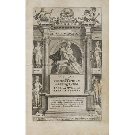
The Allegorical Frontispiece of the Atlas
The idea of encompassing the origin, structure, and functioning of the cosmos in a vast encyclopedic synthesis is clearly reflected in the architectural frontispiece of the work. It features allegorical figures representing the continents and globes, with Atlas positioned at the center.
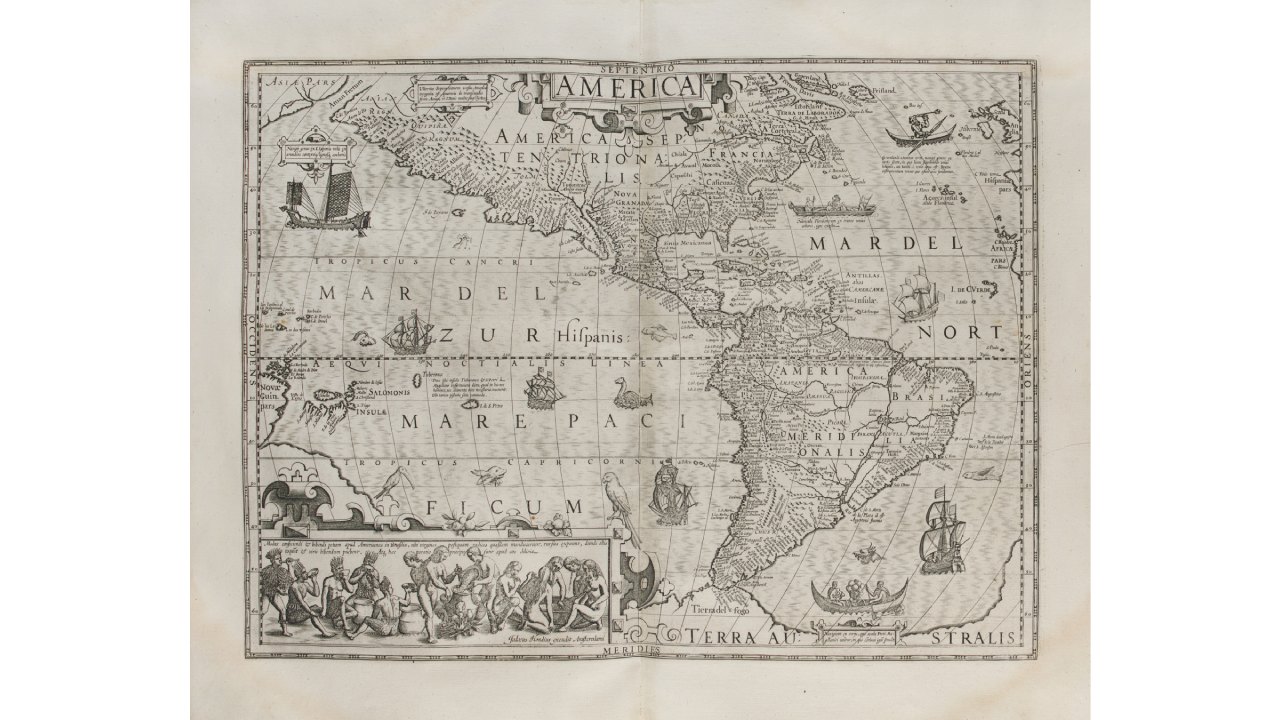
Mercator and Hondius' America
Until 1630, this map was published alongside Mercator’s America sive India nova. It includes a more accurate depiction of the western coast of South America and adjusts the longitudinal width of New Spain at the Tropic of Cancer, making it much closer to reality. However, like most cartography of the time, it still depicts an expanded North American continent. A representation of Newfoundland, styled after Petrus Plancius, appears alongside a conventional depiction of the East Coast, with a more prominent Virginia than usual.
Various scenes from the early volumes of De Bry’s Grand Voyages adorn the map. Particularly notable is a scene depicting indigenous Brazilians preparing a local beverage, inspired by Hans Staden’s travels and recorded by De Bry. The scene is enriched with ships, kayaks, and Indian canoes.
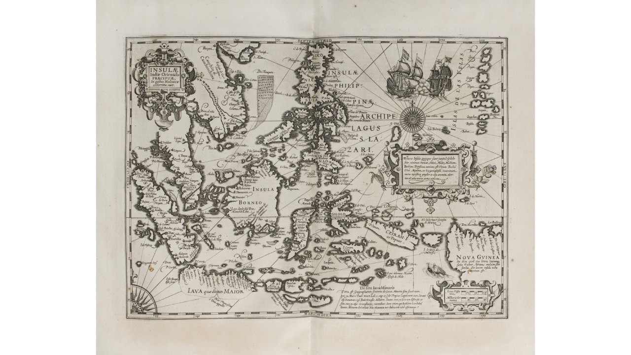
The East Indies Archipelago in the Mercator-Hondius Atlas
For the expanded 1606 edition of the Atlas, Dutch cartographer Hondius created two magnificent new maps of Southeast Asia One covering the Indian Ocean region and the other focusing on the islands. Geographically, Hondius largely followed the model established by Bartolomeu Lasso. Insulae Indiae Orientalis is one of the few maps to depict traces of Francis Drake’s presence in Southeast Asia.
The Mercator and Hondius Atlas at Bolaffi Auctions
At the Rare Books and Autographs auction on June 17, 2025, organized by Asta Bolaffi, a fine complete copy of Atlas sive Cosmographicae meditationes de fabrica mundi et fabricati figura by Gerard Mercator and Jodocus Hondius, in the 1630 Amsterdam edition, will be up for sale. The folio-format volume features an architectural frontispiece, a double portrait of Mercator and Hondius, and 164 uncolored double-page maps. It is bound in contemporary half-sheepskin with corner reinforcements, and the spine features a gilt title on a leather label. Compared to the previous edition, it includes nine new maps. The starting estimate is set at €15,000.